Land Use
The land use that makes up any rivers watershed is vital in understanding that rivers health. Land can be split into sections of urban, agricultural, and forest/wetland. Each of these have impacts on the levels and type of pollution that are occurring. Urban runoff results from city impermeable surfaces and consists of mainly storm water, while agricultural runoff consists of mainly nutrients from manure (used as fertilizer or from chicken farms). Forests and wetlands play an important role in slowing down runoff, and absorbing excess nutrients. It is important to have a large amount of these within the watershed of a river to minimize human impacts.
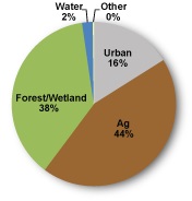
Land use within the Wicomico's watershed according to a US Census
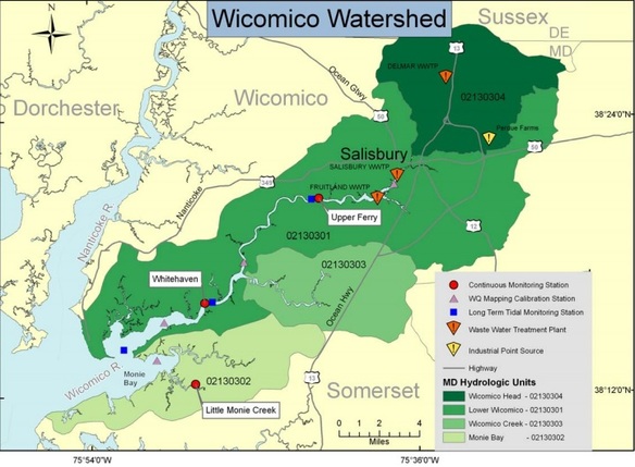 Taken from a DNR water quality assessment report in 2006. (Click picture for more).
44% of the watershed land is devoted to agricultural purposes. The 38% being forest / wetland is important for trapping runoff and maintaining a decently healthy river. With modern agriculture comes all sorts of nutrients, predominately nitrogen and phosphorus. These nutrients can come from fertilizers as well as animal manure. There are lots of chicken houses that result from the poultry industry, and these can play a large role in nitrogen and phosphorus pollution. 16% of the watershed is Urban area, which also provides it's own pollution in storm water and waste. City impermeable surfaces prevent water from absorbing into the ground and cause water to runoff into nearby water sources. On the way, this can pickup chemicals and trash from streets and lawns. Wicomico Creekwatchers provides annual reports on water quality within all parts of the Wicomico. These reports include levels for nitrogen, phosphorus, chlorophyll, and water clarity.
How does this affect the ecosystem?
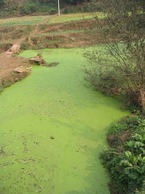 Algal bloom (Source: Wikipedia).
Nitrogen and phosphorus are considered nutrients. In excessive amounts they lead to algal blooms. Algal blooms are bad for the water because they block sunlight from reaching the lower regions of the river. This can disrupt the entire ecosystem by creating "dead zones". A dead zone is an area in the water where oxygen is no longer present, and therefore cannot maintain life. These are created when algae decays because the process consumes dissolved oxygen until there is eventually none left to consume.
Algal blooms are not the only problems that a nutrient-rich river can suffer from. Water clarity is important to sustain underwater grasses, which obviously need sunlight to survive. A healthy level for the Wicomico's water clarity would be 3 feet. Due to excess amounts of suspended sediment this can only be found in a few places north of Salisbury. Suspended sediment can result from multiple sources such as high turbidity, high tidal influence, shoreline barriers, or even dredging. Together these two issues cause a loss of biodiversity that would otherwise flourish in rivers like the Wicomico.
Algal blooms are not the only problems that a nutrient-rich river can suffer from. Water clarity is important to sustain underwater grasses, which obviously need sunlight to survive. A healthy level for the Wicomico's water clarity would be 3 feet. Due to excess amounts of suspended sediment this can only be found in a few places north of Salisbury. Suspended sediment can result from multiple sources such as high turbidity, high tidal influence, shoreline barriers, or even dredging. Together these two issues cause a loss of biodiversity that would otherwise flourish in rivers like the Wicomico.
