History of the River
|
Wicomico River and surrounding area Then:
|
Wicomico River and surrounding area Now:
|
A Comparison of Past and Present Day
Native American History of the Region
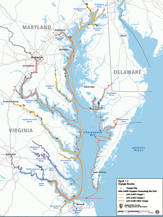 Source: National Park Service - Captain John Smith Chesapeake National Historic Trail,
Draft Comprehensive Management Plan and Environmental Assessment (September 2010)
Source: National Park Service - Captain John Smith Chesapeake National Historic Trail,
Draft Comprehensive Management Plan and Environmental Assessment (September 2010)
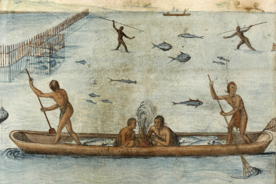
The earliest recorded history for this region (Delmarva) comes from explorer Giovanni da Verrazzano who arrived to the nearby Atlantic Coast briefly in 1524. Captain John Smith was next in 1608 who made his way up the Pocomoke River. His overland hikes brought him in contact with the Wighcocomoco, the Nause, the Kusk'arawack, and the Nantaquack or Nanticoke tribes. Smith records that the Wicomico had their own distinct dialect and appeared to be generally shorter than the people he met further south.
Native American villages and early European towns were founded on or near rivers for convenience and
many human needs. As European commerce increased, and ships became more efficient rivers became even more important for transportation and economic wealth. By 1635 the total count of European settlers was hovering around 5,000 in the Chesapeake region, but population growth hardly stopped there, and in fifty years population increased from 19,500 in the year 1700 to 144,000 in 1750, and eventually by 1800 it reached a grand total of 1,150,000 people. The Native American People were slowly pushed off their land due to the overwhelming number of Europeans settlers encroaching on their lands.
The history of a river and landscape begins with its creation, not merely with it’s use and occupation by
humans, however it is through and by human occupation that we begin to record our interactions with such an important natural resource. Before the European presence, Native People occupied the
landscape and in their spoken language created a series of records we refer to as “oral history.”
|
This process of passing on information from one generation to the next had proven very effective until the period when Native Peoples were driven from their lands and made refugees. Early colonial records reveal recorded bits of information, helping to preserve Native history. These primary records include, but are not limited to; judicial records, land patents and deeds, correspondence between European settlers and colonial authorities; treaties and colonial proclamations. Based on research into these documents we find the following:
|
The river known today as the Wicomico, located on Maryland’s Eastern Shore, was first referred to by the Indigenous People, specifically the “Rockawakinmany” People, as the “Rockawoakin.” (1) This river would eventually appear on maps by the name Wighcocomoco, and Wicocomoco, both spellings are phonetic based on the writer’s interpretation of the word and both versions translate from the Algonquin language to “where they are building houses,” (2) referring specifically to Native houses.
As most Native words were eventually corrupted by dropping syllables to make pronunciation easier by the
English, the river name evolved into Wicomico. Why did the river’s name change from Rockawoakin to various forms of Wicomico? To answer that question, we have only to go back in time to the mid 1600’s when the colonies of Virginia and Maryland were trying to establish a boundary on the Eastern Shore. Early records reveal that the infamous Col. Edmund Scarborough, (also spelled Scarborough) Surveyor-General and Treasurer of his Majesty for Virginia, (3) attempted a scheme to move the Virginia boundary on the Eastern Shore by approximately thirty miles northward by relocating the name, Wighcocomoco, originally placed on Captain John Smith’s map of 1612 for the Pocomoke River, and applying it to the Rockawoakin. While this effort ultimately failed to change the line between Virginia and Maryland, it would forever change the name of the river from the name given by the Native People.

The Rockawoakin/Wighcocomoco/Wicomico River was not explored by the earliest explorers such as Giovanni da Verrazzano in 1524 nor Captain John Smith in 1608 and is not depicted on the 1612 map based on Captain John Smith’s exploration of the Chesapeake. In time the river and its’ inhabitants
would be visited by early fur traders such as Christopher Nutter and others. Many Native villages existed along the present-day Wicomico River, including a village on the north side of the river, referred to by the European name, Cottingham’s Creeke. Another village of note along the south side of the river was called Tundotank by the Native People and was located near the present-day residential subdivision known as Tony Tank, whose name undoubtedly comes from a corruption of the Native village name.
Both Cottingham’s Creeke and Tundotank, along with many other Native towns, were set aside as reserved land through a 1678 proclamation by the colonial government of Maryland, not to be settled by colonists. (4) Eventually all these reserved lands would be patented by European settlers, forcing the Native People to congregate at other locations to include Askiminokonson Indian Town (5) near present day Snow Hill, MD and Broad Creek Indian Town near present day Laurel, DE. This encroachment would continue until there was no refuge remaining except for undesirable necks of land along small creeks and marshes where assimilation would eventually take place or migration out of the area entirely.
Many historic records and oral histories reflect the migration of Native Peoples off the Eastern Shore of Maryland and Delaware northward as far as Canada. (6) The town of Salisbury was founded in 1732 at the head of the Wicomico River, a tributary on the East side of the Chesapeake Bay. The river was used as a highway in these days and because Salisbury is the farthest boats could go inland, it was and continues to be an important port for boats trying to bring goods from different places. “Cargo once consisting of produce and fish, has become grain, fuel oil, fertilizers, and construction aggregates. The progression of commerce on the Wicomico has also affected the river itself and the landscape on the river. Shallow depths, which once limited travel on the Wicomico have given way to a dredged channel as mills and steamboat wharves have become docks for barges.” There is $200 million worth of goods brought through Salisbury’s port as of 2014, an amount great enough to make Salisbury the second busiest port in Maryland behind the famous Baltimore as of 2014
Information above courtesy of Norris C. Howard, Jr., Council Member/Secretary Pocomoke Indian Nation, Inc.
Sources:
1.) 1 Somerset County land records mdlandrec.net Maryland State Archives Liber L 1 1690’s Pages 84-85-85- 87
2.) https://www.jstor.org/stable/1004837 - John Heckewelder and Peter S. Du Ponceau
3.) Old Somerset on The Eastern Shore of Maryland, A Study in Foundations and Founders by Clayton Torrence, 1935, Richmond, Virginia – Whittet & Steppherson. Pages 28-38.
4.) Maryland State Archives; Proceedings of the Council of Maryland, 1678-1679, pages 235, 236, March 13, 1678 entitled, “Protection to Indians…, A Proclamation.”
5.) Ibid
6.) Oral History, Pocomoke Indian Nation, PocomokeIndianNation.org
Images courtesy of Chesapeake Bay Program
