Wicomico River Stewardship Initiative
  • Home
  • Nature
    • Wildlife >
      • Herps
      • Birds
      • Mammals
      • Native and Invasive Species >
        • Nutria >
          • Nutria on the Middle River
        • Phragmites
      • Food Webs >
        • Upper River
        • Middle River
        • Lower River
    • River Systems >
      • Upper River >
        • Leonard Mill Pond
        • Johnson Pond
        • Schumaker Pond
        • Tony Tank Pond
      • Middle River >
        • Land Use
        • Dredging
        • The Edges
      • Lower River >
        • Bay vs. River
        • Ellis Bay
        • Monie Bay
        • Landscape
    • Water Quality >
      • Wicomico Creekwatchers
  • Things to Do
    • Boating >
      • Access
      • Paddling >
        • Beginners Guide
        • Paddle Trails >
          • Schumaker Pond
          • Rockawalkin Creek
          • Wicomico Creek
          • Cherrybridge Creek
          • Shiles Creek
          • Johnson Pond
          • Leonard Pond
      • Motor Boating
    • Fishing >
      • How To Fish
      • Common Species
      • Places To Fish
      • Bait & Tackle Locations
      • License & Regulations Information
      • Fishing Tournaments
    • Hunting >
      • Ellis Bay WMA >
        • Regulations
        • Map
        • Directions
      • MD State Laws
      • Waterfowl Species
      • What to Bring List
      • Safety Tips
      • Ammo and Supplies Locations
      • Ward Museum
    • Other Shoreline Fun >
      • Dining, Night Life, and Local Spirits
      • Public Parks, Trails, and Exhibits
  • Life on the River
    • History of the River
    • Living on the River >
      • Joan Maloof
      • Sam Gibson
      • Jess Parsons
      • Tyrone Stevenson
      • Lynne Peverley
    • Working the River >
      • John Barnette: A Wicomico Waterman
      • Bobby Bean: Whitehaven Ferry Captain
      • Glen Lay: Port of Salisbury Dock Master
    • Tell us what you do!
  • Get Involved
    • Partners
    • Take Action
    • Hot Topics
  • About Us

Ellis Bay Wildlife Management Area

Picture
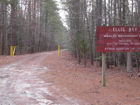
Ellis Bay WMA is located in southwestern Wicomico County on Muddy Hole Road. From U.S. 50, take MD 349 west to Capitola Road, south to Trinity Church Road, west to Muddy Hole Road and Ellis Bay WMA. Marked parking areas located off Muddy Hole Road (Longitude and Latitude: 38.268653, -75.839129)

Ellis Bay Boat Ramp:

Picture
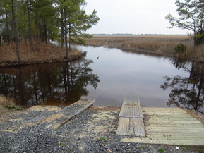
With Trinity Church Road on your right, make a left off of Muddy Hole Rd which will lead you to launching your boat. Keep in mind this boat ramp and its location is designed for boats that travel in shallow waters and is not designed for bigger vessels (Longitude and Latitude: 38.265417, -75.856394)

Mt. Vernon Boat Ramp ***I would launch at Mt. Vernon when wanting to hunt on main part of the river to prevent hitting bottom!

Picture
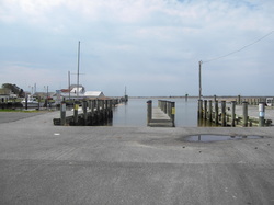
When going U.S 13 South make a right onto Mt. Vernon Rd between the McDonalds and Goose Creek in Princess Anne. Take Mt. Vernon nearly all the way down (roughly 8 miles) and and look for a sign directing traffic to turn right onto Dorsey Rd leading to the Mt. Vernon boat ramp (Longitude and Latitude: 38.248040, -75.830093)
**From here by boat Ellis Bay is across the Wicomico, look at maps to identify WMA and look for yellow boundary signs that mark off the public hunting land

Powered by Create your own unique website with customizable templates.