Bay vs. River?
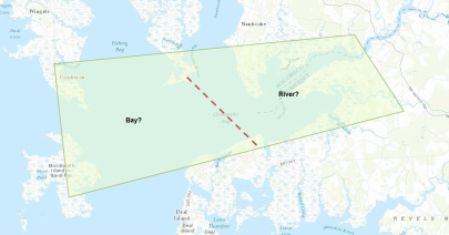
This is a divide that seems to be in question for many rivers, in this case the Wicomico, where does the river stop and the bay begin? Does it rely on salinity measures? The species of plants and wildlife? Flushing or flow of water? These are all factors to consider when making this designation but many people associate the end of the river with the end of the marshland opening into a larger, more open body of water.
On the basis of salinity the river remains brackish water south of Whitehaven until it enters into the Chesapeake Bay. The bay itself in many measures of salinity reaching the mouth is also considered brackish which opens another gray area in terms of bay vs. river. The river usually averages about 5- 10 parts per thousand of salt south of the Port of Salisbury, while the bay has an average salinity of 13-17 parts per thousand, but can vary on the basis of weather, location and season. Also basing the bay vs. river debate on plants and wildlife results instead salinity becasue of species overlap and migration from salt to fresh water different times of the year, can create more confusion in the answering of this question.
The mouth as it sits now is considered part of the Wicomico River although the views from the mouth are night and day compared to the Port of Salisbury farther up the river, in terms of the pristine wildlife and wetlands surrounding the mouth compared to the industry surrounding the port. A different classification would not necessarily effect the areas along the river in terms of watershed implementation practices and plans because they would still fall under individual county policies for these plans, which has recently entered Phase II of the statewide WIP plan. However this may effect the counts of pollution within these plans depending on whether the pollution coming from the lower river is factored into the Wicomico or the entire bay itself.
So really the question of where the river ends and the bay begins really cannot be answered with one distinct line, it is a combination of beautiful areas that slowly transform from the Wicomico River to the Chesapeake Bay.
